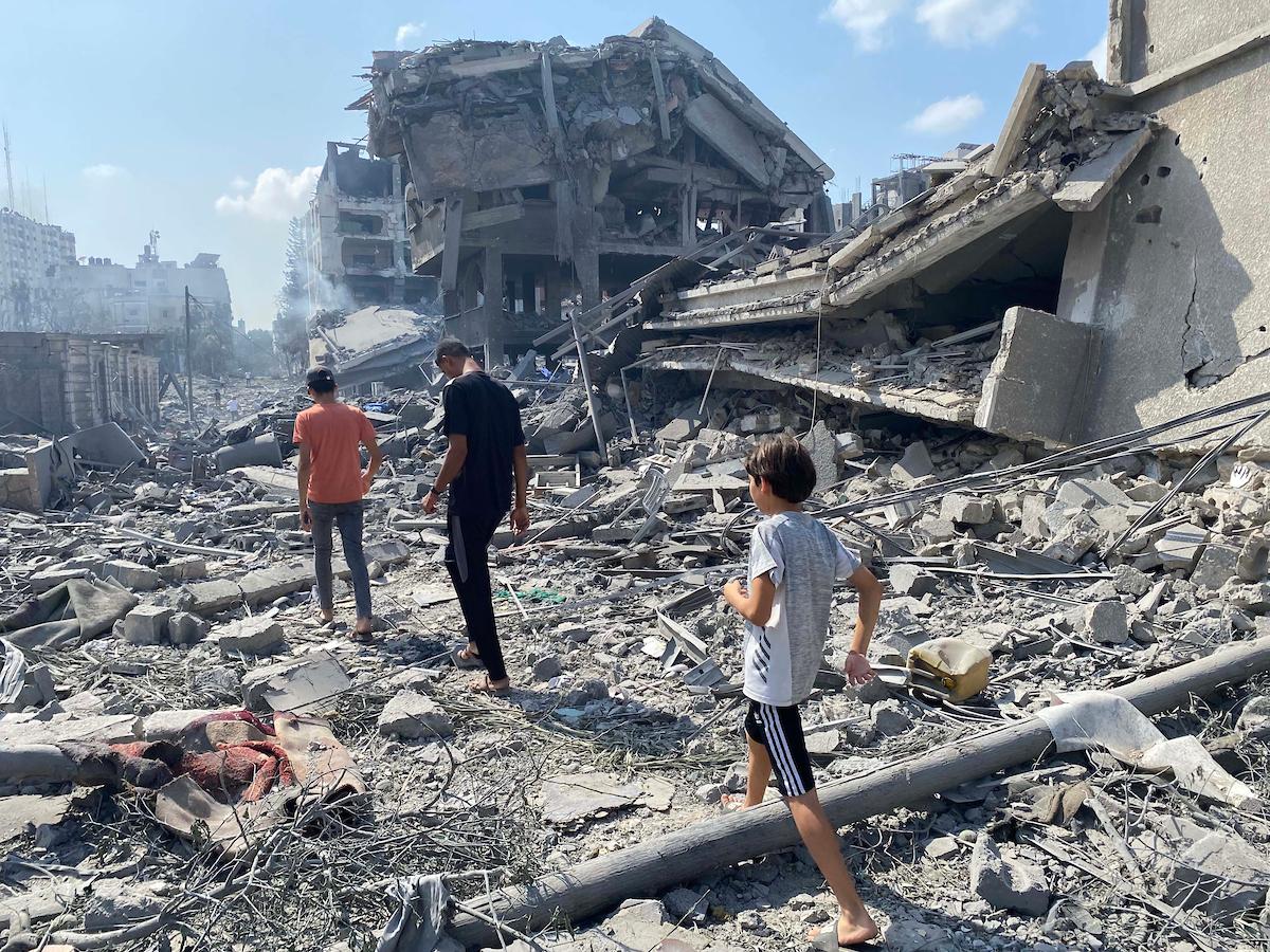
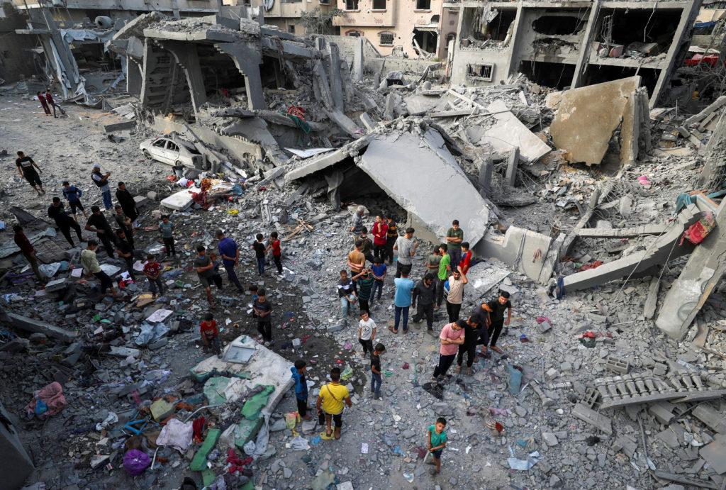
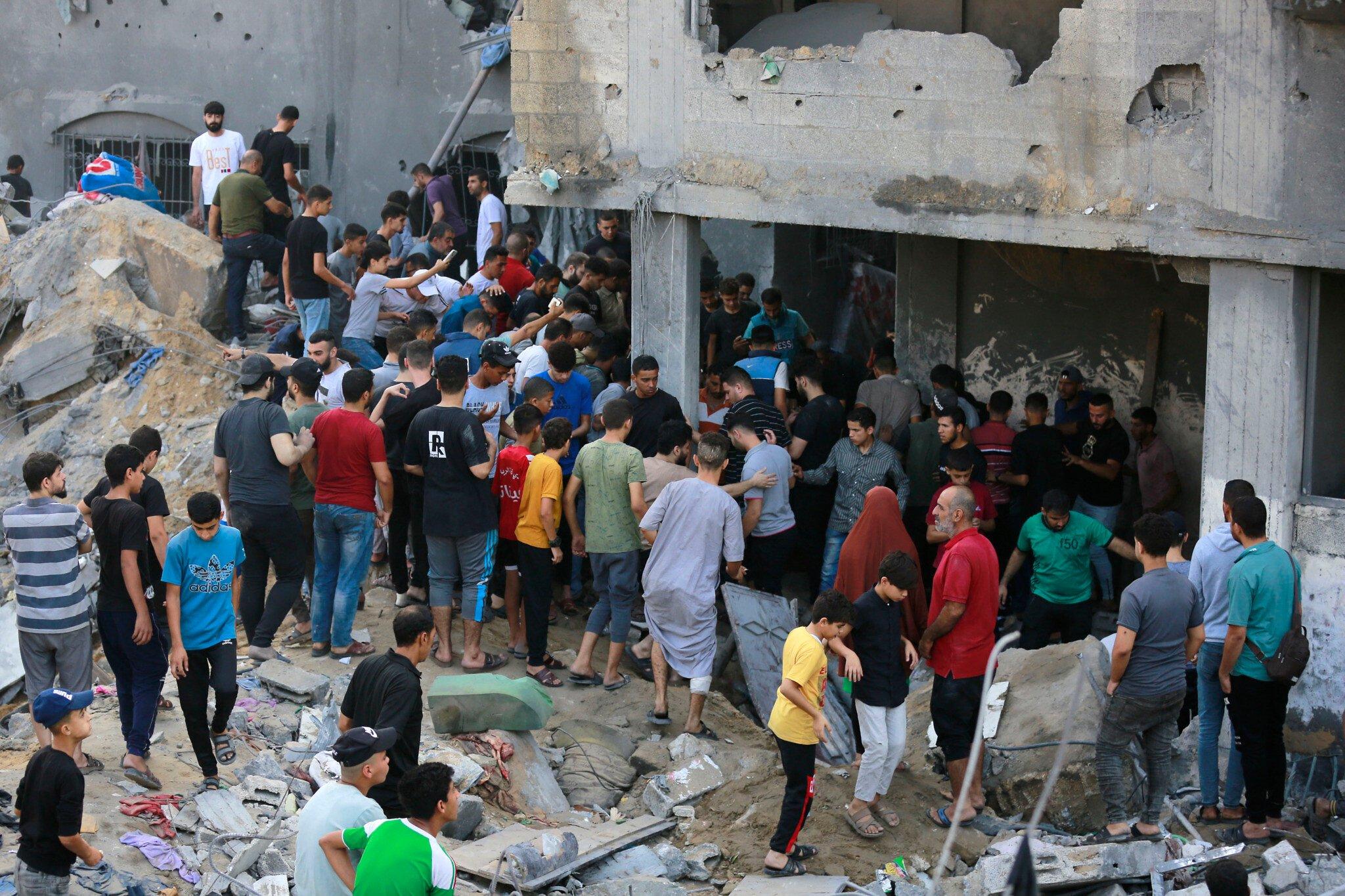
A new report suggests that only a small number of Hamas and Palestinian Islamic Jihad operatives remain in Jabalya, as the Israel Defense Forces move closer to asserting full control over northern Gaza. If confirmed, the development would mark a significant shift in a weeks-long campaign centered on one of the enclave’s densest urban battlefields, where Israeli troops have conducted repeated incursions targeting militant infrastructure and command nodes.
Jabalya’s labyrinth of alleys and high-rise blocks has made it a bellwether for the trajectory of the ground war, even as independent verification of battlefield claims remains difficult amid restricted access and intermittent communications. The reported gains come alongside mounting humanitarian concerns, widespread displacement, and ongoing international efforts to reduce civilian harm. As the front lines contract, attention is turning to what “control” might mean in practice-both for the remaining armed elements and for the civilians caught in the ruins of a fight that continues to reshape Gaza’s north.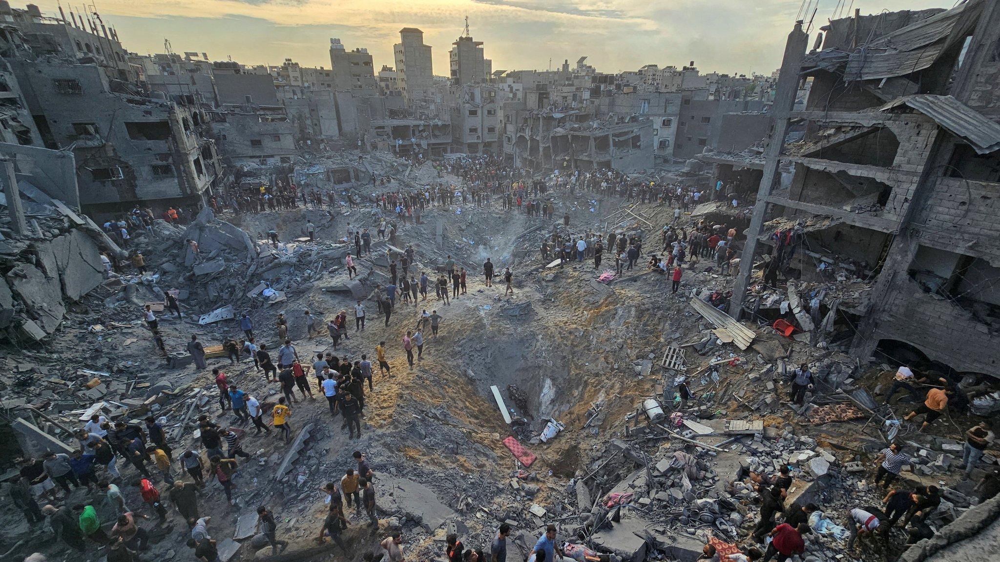
Jabalya battle map indicators of control remaining pockets of Hamas and PIJ and realistic timelines for stabilization
Recent overlays from field briefings and open-source imagery point to expanding government control marked by secured perimeters, interdicted crossroads, and persistent aerial overwatch. Small, mobile cells from Hamas and PIJ appear to linger in fragmented zones-typically in rubble-dense blocks and near suspected tunnel access points-shifting from positional defense to harassment tactics and short, coordinated ambushes. On the map, authority is visible not only in shaded “hold” polygons but in the connective tissue between them: life-line corridors kept open, repeatable patrol routes, and the gradual reactivation of essential nodes.
- Secured corridors: Main east-west lanes patrolled at clockwork intervals; aid convoys escorted on predefined windows.
- Checkpoints and choke-points: Layered screening at junctions linking Jabalya to Beit Lahia and Gaza City approaches.
- Overwatch anchors: Rooftop and UAV observation arcs covering alleys previously used for hit-and-run fire.
- EOD progress rings: Color-coded blocks indicating cleared, partially cleared, and pending unexploded ordnance sweeps.
- Communications disruption: Reduced hostile signaling in zones where command nodes were neutralized.
- Civic footprints: Aid distribution points re-appearing around schools/clinics, signaling daytime permissive security.
Stabilization unfolds in phases: first, rapid clearing and route dominance; second, methodical EOD and tunnel denial; third, essential services and regulated civilian access. Assuming deconfliction holds and weather permits persistent ISR, a measured glidepath spans weeks rather than days, with localized setbacks where residual cells attempt disruption. The cadence below reflects that rhythm-agile enough for tactical surprises, yet deliberate enough to prevent re-infiltration.
| Zone | Control Signal | Residual Threat | Stabilization Window |
|---|---|---|---|
| Camp Center | 24/7 checkpoints | Sniper/IED pairs | 7-14 days |
| Tal az-Zaatar | UAV overwatch | Tunnel-adjacent cells | 2-3 weeks |
| Al-Faluja Blocks | Patrol loops | Mortar pop-ups | 10-21 days |
| Beit Lahia Edge | Convoy lane open | Infiltration attempts | 3-4 weeks |
- Accelerators: Fast EOD throughput, intact logistics, reliable aid corridors.
- Risks to timeline: Weather grounding UAVs, fresh tunnel finds, civilian movement surges outpacing screening capacity.
- Stability markers: Nighttime noise reduction, uninterrupted aid windows, and repeatable patrols without contact.
Civilian protection first expanding aid corridors ensuring hospital access and establishing community level early warning
Civilian protection moves from aspiration to logistics when supply lines are predictable and hospitals are insulated from the shocks of urban combat. As control lines harden around Jabalya, anchor expanded aid corridors in neutral deconfliction, live convoy telemetry, and time-boxed no-strike windows, while securing uninterrupted hospital access with guaranteed fuel, oxygen, and blood products. Focus on last‑mile delivery and clinical continuity-especially trauma, dialysis, oncology, pediatrics, and maternal care-so patients aren’t forced to choose between movement and survival.
- Corridor integrity: GPS-tagged convoys, shared route hashes, and cross-checked manifests to prevent duplication and diversion.
- Hospital ring-fencing: dedicated ambulance lanes, generator fuel quotas, and fast-pass clearance for medevac within minutes, not hours.
- Mobile care surge: roving surgical teams, neonatal transport units, and trauma stabilization points positioned at corridor junctions.
- Transparent windows: publicized crossing hours in Arabic and English, with backup slots for delayed or high-priority medical shipments.
- Independent oversight: joint monitoring by neutral agencies for real-time verification and post-incident review.
| Corridor | Hours (local) | Daily Capacity | Medical Priority | Status |
|---|---|---|---|---|
| Coastal Route | 08:00-18:00 | 120 trucks | Trauma/ICU | Proposed |
| Salah ad-Din Spine | 24/7 | 80 trucks | Dialysis/Oncology | Pilot |
| Beit Hanoun Link | 10:00-16:00 | 60 trucks | Pediatrics/OBGYN | Pending |
| Hospital Ring Road | 24/7 | Ambulances | Medevac | Green |
Community-level early warning must be hyperlocal, redundant, and inclusive-carrying the same message across sirens, radio, cell broadcast, and neighborhood networks so families can move quickly and safely. Pair tech with trust: empower wardens, clinic staff, and municipal teams to validate alerts, open shelters, and guide vulnerable groups, then capture feedback to refine deconfliction and reduce harm with each cycle.
- Redundant alerts: cell broadcast in Arabic/English, FM radio cut-ins, mosque and community loudspeakers, and door-to-door runners for outages.
- Accessible design: pictogram signage, tactile cues, vibration alerts, and predefined assistants for people with disabilities, the elderly, and children.
- Live shelter map: QR codes and offline tiles showing capacity, water, power, and medical triage status; updated via low-bandwidth APIs.
- Geo-fenced guidance: turn-by-turn safe routing that auto-avoids active operations and collapses to text when bandwidth drops.
- Privacy-first reporting: anonymous incident pings and after-action check-ins to improve alert precision without exposing identities.
Verifying the narrative cross checking field reports satellite imagery and independent monitors to curb misinformation
Amid claims of dwindling militant cells in Jabalya and incremental consolidation in northern Gaza, verification hinges on layered evidence rather than single-source certainty. Analysts fuse timestamped field dispatches with commercial satellite cues and notes from nonpartisan observers, filtering noise from fast-moving narratives. Every image is tied to coordinates; every clip is traced to a probable vantage point; every statement is tested against known pattern-of-life data. The aim is not to affirm or dismiss headlines, but to reconstruct what is observable, reproducible, and responsibly contextualized.
- Field reporting: frontline contact lines, unit locations, and movement corridors compared across shifts.
- Satellite passes: debris fields, fortifications, and vehicle tracks mapped against prior imagery.
- Independent monitors: incident logs on civilian impact and access constraints for cross-reference.
- OSINT artifacts: video frames geolocated; shadows and weather patterns used for time checks.
- Humanitarian channels: convoy routes and medical facility status used as ground-truth anchors.
To curb amplification of unverified claims, a rolling matrix grades each input by reliability and recency, flagging gaps and contradictions in real time. This approach helps distinguish tactical changes from rumor, and separates what is corroborated from what remains contested while conditions evolve on the ground.
| Source | What it checks | Status |
|---|---|---|
| Field dispatches | Contact lines, movement | Cross-checked |
| Commercial satellites | Damage, fortifications | Corroborated |
| Independent monitors | Civilian impact | Ongoing review |
| OSINT videos | Geo/time validation | Verified / flagged |
| Humanitarian logs | Access corridors | Partial data |
Path forward de escalation benchmarks monitored withdrawal and plans for essential services governance and rubble clearance
As control consolidates in the north, a sustainable calm hinges on clear, verifiable steps that reduce friction hour by hour and block by block. A practical framework prioritizes civilian safety, ensures transparency around military movements, and unlocks predictable humanitarian access. Key measurable milestones can be nested within a monitored drawdown, with neutral observers publishing daily snapshots to deter violations and maintain momentum toward local stabilization.
- Ceasefire windows: synchronized, recurring pauses mapped to aid convoys and medical evacuations.
- Phased redeployment: sector-by-sector pullback linked to cleared routes and neutral verification.
- Standoff safeguards: heavy-weapon exclusion zones around shelters, clinics, and markets.
- Third-party verification: GPS-tagged patrol logs, drone imagery, and hotline incident boards.
- Detention transparency: manifest sharing, ICRC access, and family notification protocols.
- UXO/IED risk mapping: rapid survey, color-coded marking, and public advisories via SMS/Radio.
| Benchmark | Timeframe | Lead Monitor |
|---|---|---|
| Daily ceasefire window (2-4 hrs) | Immediate | OCHA/ICRC |
| Perimeter handover in northern sectors | 72 hours | UNTSO |
| Heavy-weapons standoff 5-7 km | 48 hours | Third-party liaison |
| Detention audits & notifications | Weekly | ICRC |
| UXO hazard maps published | 10 days | UNMAS |
Stabilization requires immediate restoration of essential services and a debris strategy that is safe, visible, and jobs-centered. A joint operations cell-linking municipal engineers, humanitarian agencies, and community leaders-can triage water, power, health, sanitation, and connectivity while coordinating rubble clearance with strict environmental controls. Transparent task boards, local hiring, and open data on progress help rebuild trust as neighborhoods reopen.
- Water: mobile desalination units, trucked supply, and chlorination kits at communal taps.
- Power: prefab microgrids, solar hubs for clinics, and prioritized repair of feeder lines.
- Health: temporary field clinics, medicine corridors, and ambulance deconfliction lanes.
- Waste & sanitation: emergency latrines, vector control, and regular collection points.
- Telecom: portable towers, charging stations, and SMS alerts for safe routes and aid times.
- Rubble clearance: UXO screening, designated debris sites, asbestos precautions, and cash-for-work crews.
- Governance: service compacts with local councils, public dashboards, and feedback hotlines.
Future Outlook
As the fighting in and around Jabalya appears to ebb and claims of near-complete control in northern Gaza gather pace, the contours of this phase of the conflict come into sharper focus without delivering a final picture. Military maps may change quickly; the realities on the ground-displacement, disrupted services, and the risk of renewed clashes-tend to shift more slowly.
Analysts caution that territorial gains do not resolve the underlying dynamics: fragmented command structures among armed groups, the prospect of low-intensity insurgency, and the complex interplay of regional diplomacy and humanitarian relief. Reports from the area remain difficult to verify independently, and casualty figures and operational details are likely to be revised as access improves.
For now, attention turns to what follows control: security, aid delivery, and political calculus. Whether momentum in the north translates into sustained stability-or merely a pause before the front moves-will become clearer in the days ahead.